

Yesterday Was A Giant Forecast Bust ❌
Yesterday Was A Giant Forecast Bust ❌
Let's talk about how the experts got it wrong yesterday.
The lack of soundings in the area has always haunted me when I chase in Central Or South Texas (Upper-left graphic). Yesterday is a prime example of how, if you read between the lines, the capping that showed up on 18z Corpus Christi sounding was evident in Northern Mexico a few hours prior.
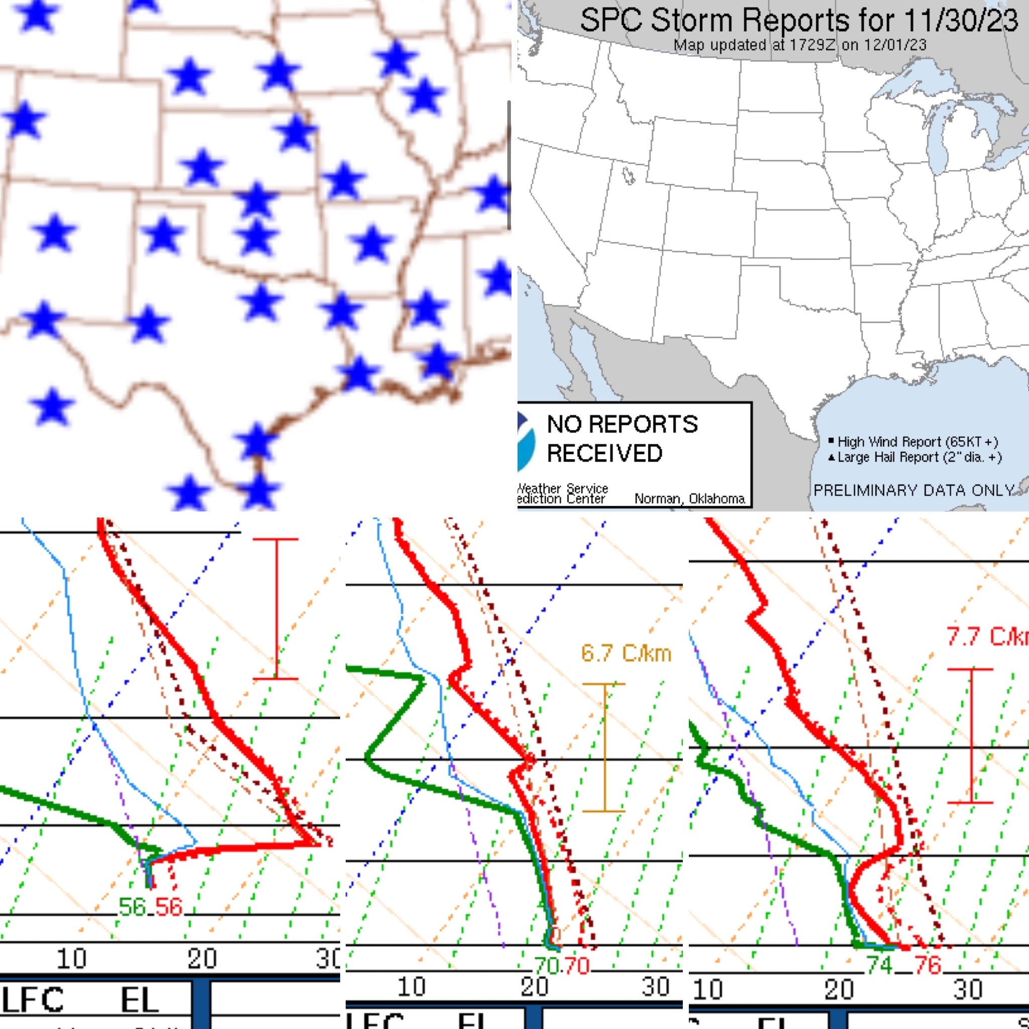
This, along with thick low clouds limiting mixing, did yesterday in before it even had a chance. There were 0 preliminary storm reports yesterday despite the day beginning as an enhanced risk. It is always important to look at why setups don’t take off after the fact, as it is essential to look at setups that do.
In the bottom-left graphic, you can see the substantial capping layer present in NE Mexico on the 12z sounding. If you checked on mesoanalysis, this was also present inland across Texas. But Corpus Christi’s 12z sounding near the coast had little to no capping in the morning. (Bottom Center)
By 18z (or noon local time), the Corpus Sounding had significant warming just above the 850mb layer. There was an erroneous dewpoint on the 18z sounding, with much lower actual moisture. This resulted in a substantial amount of CINH on a mixed layer sounding. When you combine this capping with the extremely thick cloud cover and cool surface layer further NE in the risk area, it’s not hard to see how storms failed to materialize until evening nearer the coast in Louisiana.
Days like this are always difficult to forecast because some of the factors can be tricky and surprising. If the skies had cleared in SE Texas yesterday, the odds of enough heating occurring to allow for more robust updrafts would’ve been much higher. The key lesson is, and always will be, to pay attention to observed weather data before you check in with models.
My Favorite Chase Day of 2023?
This was the quintessential Oklahoma mid-May storm chase with supercells off of the dryline, likely with tornadoes expected towards the late afternoon.
Unlike the April 19, 2023 chase, I felt the entire team had a better handle on this day and what needed to be done. We were deep into streaming storm chases and had many of the kinks in the workflow worked out.
Leaving the hotel this morning, I knew I would have a good chance to see a tornado. It was hot and humid, with dewpoints well into the 60s and even into the low 70s. With moderate wind shear and strong to extreme instability, a dominant supercell would be quite a spectacle.
Little did we know the small community of Cole, OK, would suffer its second tornado impact of the year.