

Plains Severe Weather Today
Plains Severe Weather Today
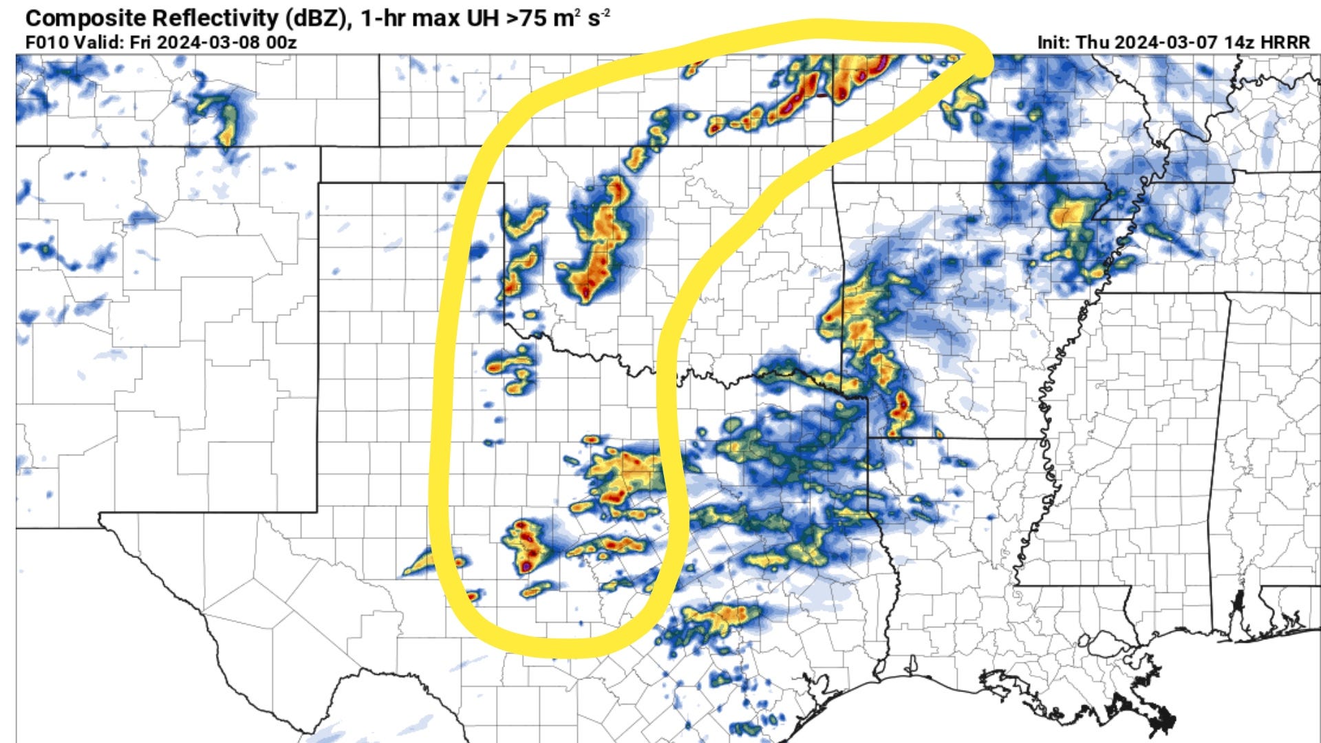
Oklahoma, Texas, Kansas all under the threat area with a very low tornado risk.
There is a slight risk of severe thunderstorms this afternoon and tonight across portions of the Southern Plains. Large hail and damaging wind gusts are the main threats. This activity has a very low tornado threat, mainly confined to any supercells ongoing near and just after sunset.
Location
Oklahoma
Kansas
Texas (especially western, northern, and central portions)
Threats
Large hail (potentially exceeding 2 inches in diameter)
Damaging to severe wind gusts
Isolated tornadoes (threat is limited due to lower moisture)
Timing
This afternoon through tonight
Discussion
Upper-Level System: A shortwave trough and several smaller disturbances will move across the Southern Plains, setting the stage for thunderstorms.
Surface Features: A low-pressure system will track across Oklahoma and Kansas, with a trailing cold front and a sharpening dryline.
Storm Development:
Isolated storms could form along and ahead of the dryline this afternoon.
The greatest concentration of storms is likely in western Oklahoma into southern Kansas, and across west-central and north-central Texas.
Storms may initially produce very large hail and strong gusts. While the tornado threat is lower overall, isolated tornadoes can’t be ruled out.
Overnight Concerns: As the night progresses, storms could become widespread, with ongoing hail and damaging wind threats.
Uncertainties
Dryline Dynamics: The exact positioning of the dryline will influence where the most severe storms develop.
Moisture Availability: The northward reach of rich, unstable air is still somewhat uncertain, making it harder to pinpoint the areas of greatest severe threat.

Scattered storms should form along a dryline this afternoon and up near a cold front in Kansas. Additionally, numerous smaller and less strong storms will be ongoing east of the dryline in Texas.

Storms will increase in intensity with time, with severe weather becoming more likely from Western Oklahoma into Southern Kansas and across West-Central Texas.

Storm mode today looks mixed, but it does appear some supercells may be able to take shape off of the dryline, especially near/after dark, as instability and wind shear markedly increase. A narrow window of low tornado potential is near and just after sunset, before the boundary layer cools.

For a more technical discussion: Initial cells off of the dryline will be dealing with a dry environment that is weakly sheared. 0-3km SRH values are pretty low, and 0-6km bulk shear values only marginally support storm organization.

In Kansas: Models are trying to pool moisture along a cold front, with much stronger shear overall. This is an intriguing possibility, but I am worried about the thick cloud cover and cold temps as well as the southward-moving cold front. To keep a storm surface-based, it is going to need to have a right motion south of east. That is possible, but the downdrafts of these storms will likely be rather cold. From a chasing perspective, the low clouds likely around these storms with crosswise shear vectors will make for a grungy appearance.

After dark in Western Oklahoma: Shear picks up quite a bit. Storms will likely remain surface-based through 7-8 p.m. This could set the stage for a brief nocturnal tornado threat in this region, with ample 3CAPE and increasing overall shear. The key at this point will be storm mode. If a storm is surface-based and supercellular and not wrapped into a surging area of outflow, it seems like a tornado is possible. But overall, this is a low-risk type of scenario. Still, it is worth watching.
Bring it!!! :)