

Dual Threat Power System Approaching ❄️🌪️
Dual Threat Power System Approaching ❄️🌪️
A whopper of a winter system will move east and strengthen rapidly, bringing blizzard conditions and severe weather.
A whopper of a winter system will move east and strengthen rapidly, bringing blizzard conditions and severe weather on its opposing cold and warm sides.
This will make for a major clash of seasons type of weather threat scenario, but one that we’ve seen many times before. Still, the impacts of this system could end up pretty high-end.
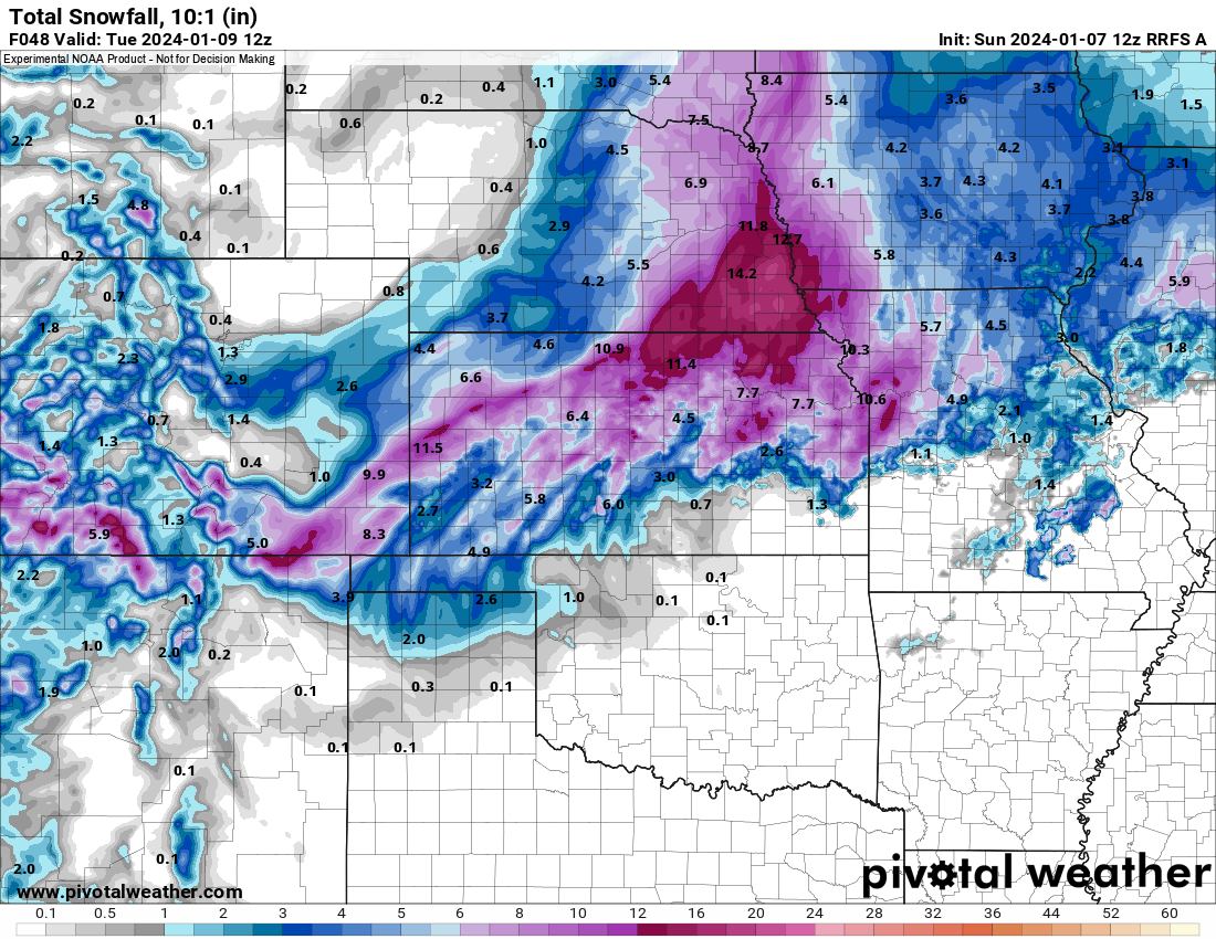
First, the winter side: Snow will pile up on the north and west sides of the surface low track, with blizzard conditions likely for many as this system lifts north and east.
The big change is the track of the system looks to be slightly more northerly according to higher resolution models this morning.
This will mean the snow line’s southern extent will be further north and west, which probably cuts out most of the Panhandles.
Moisture available to the system initially does look a hair lower than prior model runs, which, looking at the local soundings, makes a lot of sense.
Snowfall totals of 6-12” are possible across portions of Kansas/Nebraska and then back to the southwest into the northern Panhandles/New Mexico/Colorado.

Severe weather is possible along the Gulf Coast: As the system slides east, we’ll have a robust severe weather threat develop. At this point, some caveats may prevent a higher tornado risk.
The biggest question is, how far north will the warm and unstable airmass make it north? There will be storms north of that lifting warm front, but they will be rooted above the surface with a near-zero tornado threat.
Storms will form in the colder airmass, initially further north and west, across Oklahoma and Texas. There will be a very low risk of hail with these.
As the system pushes east, the odds of the line of storms encountering increasingly warm/unstable surface air rises. By Monday night, severe weather could certainly begin to peak.
Unfortunately, as the last sentence says, the bulk of the threat will be well after dark and possibly into the overnight hours. This will make for a dangerous situation — even if the overall tornado numbers aren’t high.
Thus, if you live in the South, it’s a great time to make sure your weather radio is on and programmed correctly.
The bottom line: This system poses a significant threat, impacting areas from Colorado to Florida. Today is a good day to ensure you have everything ready for this powerful system.
See Our Latest Live Forecast Discussion
This is your periodic reminder to subscribe to us on YouTube.
We do cool things like talk severe weather setups. Here’s our video from yesterday talking about this system (still thankfully up to date!).